Geology/History of the Island and Region
The
history of the island begins with geology, then continues with biology, anthropology,
history on up to current events. Here are some major dates:
|
Years Ago |
Event |
|
1,100,000,000 |
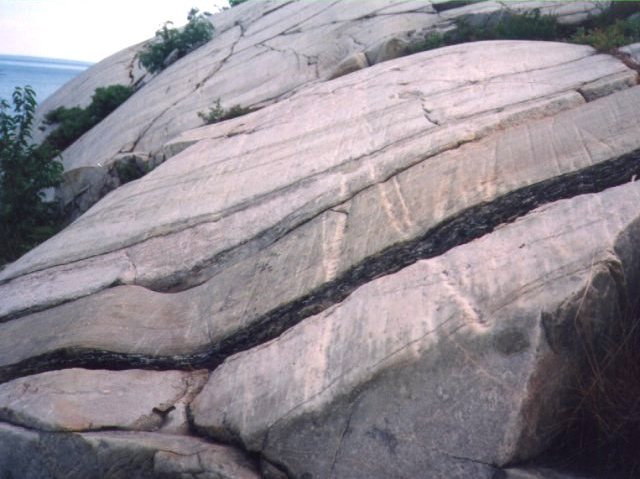
The rock that makes up “The Island” is Lorraine Quartzite. This rock was sand on a beach 1.1 billion years ago. The Earth was very different then, there were not any life forms more complicated than bacteria. It was at this time that the continents began to drift apart form the original single land mass. This was during the middle to late Precambrian era. Quartzite is typical of the peninsula leading out to McGregor Point and the Benjamins. |
|
620,000,000 |
First life forms appear, invertebrates and mosses, algae slightly earlier. |
|
490,000,000 |
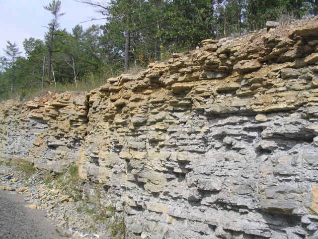
Tan limestone (shale) is on the mainland, Manitoulin Island and many of the small islands. It is from the Middle and Upper Ordovician period of the Paleozoic era, fish appear, no land animals. At this time the area that became Manitoulin Island was covered by a shallow tropical sea. |
|
230,000,000 |
Age of Dinosaurs |
|
55,000,000 (55 Million) |
North American continent separated from the European continent |
|
10,000,000 |
North American continent joined with the South American continent |
|
1,800,000 |
Beginning
of the most recent ice-age |
|
30,000 |
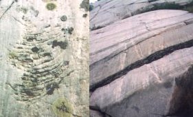
Click on the pictures above for more detailed info on glaciation both on the island and in general. Around
this time man migrated to North America. |
|
13,000 |
Younger
Dryas A rapid but short term cooling trend lasting about 1,000
years. Prior to this time the Clovis
People were the only ones in North America. They appeared to be
become extinct during the Younger
Dryas and were replace buy Folsom
People.
At this time many animals such as the Mammoths, short-headed bears, ground sloths and camels became extinct in North America. The extinction may have been due to over hunting or the climate change. The climate change may have been due to the flooding of a large amount of fresh water from melting glaciers in to the ocean or possibly from the impart of a comet. |
|
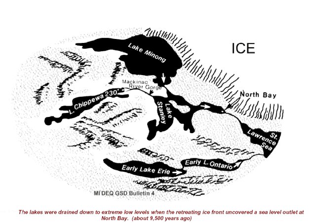
10,000 |
End of the last Ice Age and the appearance of man in the area.
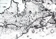
Lake Huron did not drain south through the Detroit River as it does now. Instead, the northern Great Lakes drained through a channel near present day North Bay and and down the Mattawa River to the Ottawa River Valley and on to the Saint Lawrence at Montreal. North Bay is on the eastern end of Lake Nipissing and about 75 miles east south east of Sudbury. Lake Nipissing is the headwaters of the French River. There was a river gorge connecting Lake Michigan to Lake Huron It was only after the land in this area had rebounded from the weight of the ice that the Great Lakes drained through the St. Clare River to Lakes Erie and Ontario as they now do. This route was later used by fur traders, it required some portaging by then but avoided hostel Indians and hostel settlers (around Detroit after the rebellion in the lower colonies.) and was shorter with less open water. |
|
9,000 |
The first signs of Indians on Manitoulin Island (and Ontario in general) date from this period. They were called Plano. They hunted mastodon and caribou with quartzite spears. They left an ancient quartzite quarry at Sheguiandah (A little south of Little Current on highway 6.) They lived in what is called the "Palaeo-Indian Period" |
|
Year |
Event |
| 5,000 - 500 BC | Archaic-Indian Period first use of copper. Fishing was a major source of food. |
| 1800 BC | With the removal of the crushing weight of the ice, the land began to rebound slowly and unevenly. The McGregor Bay area is still rising at a rate of about 35 centimeters (13 inches) per century but the Chicago area is not changing any significant amount. By 1800 BC the Great Lakes stopped draining out through the Lake Nipissing area and switched to the St. Clare River. Georgian Bay still extended to Lake Nipissing |
| 800 BC | The land rose enough to separate Lake Nipissing from Georgian Bay and the French River was born. |
| 500 - 800 AD | Middle Woodland Period. The introduction of decorated pottery and net fishing are some of the characteristics of this period. |
| 800 - 1600 AD | Late Woodland Period. Fishing moves offshore and semi-permanent summering villages are established. |
| 1500 AD |
Ojibwa (Chippewa) around the Soo area.
They were a member of the Algonquian linguistic family and call themselves
Anishnaabe meaning "original man. The Algonquin tribes
extended from mid Georgian Bay and along the northern shore of Lake
Superior up to Hudson's Bay. They were principally hunter-gathers. Their legions say they came from the shores of the great
salt water towards the rising sun. All this land is part of the Canadian
Shield and is characterized by relatively poor rocky soil with lots of
lakes and bogs. In all the area of Ontario South of Georgian Bay and extending into northern New York Sate were the tribes in the Iroquoian linguistic family. The Hurons were between Georgian Bay and Lake Simcoe (south east of Georgian Bay). This area was called Huronia. In the 1700s under pressure from the Iroquois, the Hurons moved first to Michigan, then to Wisconsin and Illinois, where the Sioux attacked them. The five Nation Iroquois were in Upstate New York. These tribes were predominantly horticultural living on corn, beans and squash and living in well fortified villages. |
| About 1612 | Eighteen-year-old Etienne Brule, who worked for Samuel de Champlain, was the first white man to travel through the North Channel. He had come from Quebec down the French River to Georgian Bay where he spent 3 winters with the Hurons near what is now Midland at the south end of Georgian Bay. (He may have gone overland to Midland initially, I am researching the point) |
| 1616 |
 Champlain: Champlain:"With Indian guides we traveled up the Ottawa River, over portages to Lake Nipissing, crossing the lake, then down La Riviere des Francais to La Mer Douce, Sweet Sea (of Georgian Bay)." They were given a small amount of corn and squash by the Indians (Hurons) along the way. Champlain encamped with the Cheveux Releves (high hairs) on the North Channel, an encampment of about 300 Ottawa that were there for berry picking. |
| 1616-1649 | Hurons controlled the fur trade with parties as big as 150 canoes and 700 men. |
| 1634-1641 | Over half of the Hurons in the Great Lakes area died from diseases brought by the white men from Quebec. The death rate among the Ojibwa and other Indianans of the North may have been even worse. |
|
1648-1649 |
War between Huron and League of the Iroquois (League
of 5 Nations) destroyed the Huron
nation. The Iroquois wanted to extend their control of the fur trade.
The League of 5 Nations consisted of the Mohawk, Onondaga, Oneida, Seneca, and
Cayuga. The Iroquois had already depleted the beaver in upstate New
York.
The remaining Hurons moved first to Michigan and Ohio, then to Wisconsin and Illinois, where the Sioux attacked them. The Ojibwa were temporarily driven back towards their stronghold at Sault Ste. Marie. The Iroquois had the advantage of more guns since they were trading with the Dutch in New York. The Dutch were more willing to trade furs for guns then were the French. [The Dutch controlled the Hudson River Valley from New York (New Amsterdam) to Albany (Fort Orange) from 1609 until 1664] |
| Early 1654 | Peace made with the Iroquois reopened the Ottawa-French River route to trade. From this point on, French and English traders took on a bigger and bigger share of the fur trade from the Indians – although some of the Voyageurs continued to be Indians. Virtually all the trappers remained Indian. |
|
1650 |
|
|
1670 |
Hudson Bay Company formed and sets up several forts along major rivers
leading into James Bay and Hudson Bay.
The French control the fir trade on the Great Lakes. Liquor is a major inducement to get the Indians to trade for furs and has a devastating effect on the Indian communities. |
|
1690 |
The southeastern Ojibwa expanded from their base around Sault Saint Marie (Probably including Manitoulin Island) into southern Ontario and Michigan – forcing out the Iroquois that have moved into southern Ontario. They finally expanded to upper Wisconsin and Minnesota, as well as southern Manitoba and south eastern Saskatchewan. |
| 1701 | Ojibwa and Iroquois signed a peace treaty which basically removed the the Iroquois from Ontario. |
|
1754 to 1763 |
The
French and Indian War ended when the French lost their last stronghold
in Canada with their loss of Montreal. The defeat was formalized at the
Treaty of Paris in 1763. The French and Indian war was part of a
larger conflict between England and France called the 7
Years War.
For more detailed information about the conflict check out the French and Indian War Resource Guide. Fort Michilimackinac built by the French in 1715 becomes an English possession. The Ojibwa had sided with the French because they feared the English were more likely to confiscate their land. The English were also more arrogant trading partners. |
| 1781 | British move Fort Michilimackinac to nearby Mackinac island renaming it Fort Mackinac. The new fort is made of Limestone rather than wood and situated in a much more defensible position. |
| 1797-1812 | The North West Fur Company built locks at the Soo on the Canadian side that could handle small boats up to 38 feet long. They were destroyed during the war of 1812. |
| 1812 | War of 1812 Ojibwa side with the British and help take and defend Fort Michilimackinac. |
| 1821 | North West (Fir) Company amalgamated with The Hudson Bay Company and diverted all fur trade from the Lake Superior area up to their facilities on Hudson Bay rather than send the furs through the North Channel and Lake Huron route. |
| 1836 | The British convince the Indians of Manitoulin Island to sign a treaty to accept Indians from other parts of Ontario. They hoped to make the island a large Indian reservation and open the remainder of Ontario east of Georgian Bay and Lake Huron to settlement. The plan does not work. Most of the Indians who come to the Island were from the United States. |
| Late 1830s | First steamers appear (Wood burning) |
| 1850 | Fashions in Europe change, the hats made from felt derived from beaver fur goes out of fashion to be replaced by the silk hat. This signals the end of any significant fur trade. |
| 1855 | New locks were constructed at the Soo. The "Michigan" locks could handle boats up to 350 feet long. (The biggest current locks, the Poe locks can handle boats up to 1,200 feet long and 110 feet wide. This is somewhat larger than the largest boat that can traverse the Panama Canal, Panamax. |
| 1862 | Treaty opens up Manitoulin Island to white settlement. Wilkwemikong Chiefs refuse to sign and still have not. |
| 1870s | Logging becomes big along the North Channel. The forests of Michigan have been mostly depleted so there is a great export market. |
| 1885 | Trans Canada Railroad opened, some of the parts above Lake Superior along with the mountains in the west were the last sections to be completed. |
| 1890s | Peak of the Fishing industry. Killarney is the biggest player. Most of the fish are salted and exported to the US. |
| 1943 | Franklin D. Roosevelt spent 3 days fishing in McGregor bay during a stopover on his way to a meeting with Winston Churchill at Quebec City. The Quebec Conference laid the groundwork for the Normandy Invasion (June 5, 1944) and the war in the South Pacific. A stone memorial marking the occasion is on Highway 6 at Birch Island, the first nations reserve north of Little Current where Roosevelt's special train was parked during his visit. |
|
About 1954 |
Half of the island burned in the spring (Particularly the area between where the outhouse is now and the water). The cabin was built that summer. The island had been purchased from the Province the year before. |
| 1962 | Road opened up to Killarney. Prior to this time the only access was by boat in the summer and a road over the ice from McGregor Bay in the winter. The ice road went past the Island. |
| 1964 | Record August low water, 2 feet 9 inches below the average level for the month, 9 inches below the chart datum. |
| 1986 | Record August high water, 2 feet 7 inches above the average level for the month, 4 feet 7 inches above the chart datum. |
| 2006 | Island Sold |
| Dec. 18, 2008 | David Whitaker Died. Dave was the principle person who used and maintained the island for many years. |
References and general background info:
French River Trail to the North Channel was used by the Voyageurs as a water highway to the west from 1600-1800s. It was shorter with less open water then the route through the Detroit River, and avoided Detroit which was at times occupied by a hostile power (The English or US). This route also avoided problems with raiding parties of Iroquois that were a particular problem in Lake Ontario. The river begins at the South West corner of Lake Nipissing, about 80 kilometers (50 miles) east south east of Sudbury. Read French River, Canoeing the River of the Stick-Weavers by Toni Harting for more detail, wonderful pictures, excellent maps and available from amazon.com. This route is approximately the route taken by the outflow of the great lakes about 10,000 years ago, see above.
Caesars Of The Wilderness - Company Of Adventurers - Volume 2 by Peter C. Newman is a good book about the Voyageurs. It is out of print but available from a number of used book stores. See http://www.bookfinder.com
A good general history of the North Channel area is: The North Channel and St. Mary's River: A guide to the History by Andrea Gutsche, Barbara Clisholm, and Russell Floren. Published by Lynx Images, ISBN 1894073002 http://www.lynximages.com/normainone.htm
A good archaeology site is maintained by Ontario Archaeology Society, another by London Ontario Museum of Archaeology
A brief history of the fur trade is available from the White Oak Society in Deer River Minnesota
Another is maintained by the Canadian Museum of Civilization in Ottawa..
Janie Lynn Panagopoulos has a great set of children's books some of which deal with related subjects. She was the one that recommended the book on the French River. She has also been to the Island.
Rev 6/9/15